Saturday, January 06, 2007

A Classic Farmhouse


This old home is located on Champe Ford road, south of route 50.
coordinates:
N 38.9687667
W -77.66893333

Chrysalis Viewshed


This is the view from Chrysalis Vineyards
Vineyards looking east toward Bull Run Mountain and the Gilbert's Corner area. The area on the visible side of the mountain is already being developed. I noticed several signs for new homes pointing up New Mountain Rd.
Chrysalis is located on Champe Ford Road, between Aldie and Middleburg.
coordinates:
N 38.95831667
W -77.67365

A Map Showing All The Recent Spots Profiled Here

Thursday, January 04, 2007

Loudoun County Halts All Rezoning For 12 Months!

Note: The only board member opposed to this was Snow who represents the areas profiled on this site. I'm sure Toll Brothers was heartened by his sympathetic stance towards the need to make every surface in Dulles South impervious to water.

By Amy GardnerWashington Post Staff WriterThursday, January 4, 2007; Page B10
After barreling through most of this decade as Virginia's fastest-growing community, Loudoun County sent a loud message to Richmond and its own traffic-choked residents yesterday by voting to halt residential rezoning applications for 12 months.
In so doing, the Board of Supervisors joined a growing list of Washington area communities seeking to urge state officials to find more money for road improvements and to appease fed-up constituents in an election year.
'After barreling through most of this decade as Virginia\'s fastest-growing community, Loudoun County sent a loud message to Richmond and its own traffic-choked residents yesterday by voting to halt residential rezoning applications for 12 months
Prince William County adopted a similar building freeze last month that, as in Loudoun, was viewed as largely symbolic. In both jurisdictions, rezoning applications generally take at least 12 months to gain approval, so the practical implications are limited.
But the symbolism is significant in a year when the General Assembly, which convenes Wednesday, is planning to devote unprecedented attention to questions of growth management and traffic. Gov. Timothy M. Kaine (D) is traveling to Northern Virginia today to announce proposals to raise taxes for roads, improve the state transportation department and give local governments more power to control growth.
"Richmond has to pay," said Loudoun Supervisor Lori Waters (R-Broad Run). "Richmond has to do its job."
The Prince William board approved its freeze unanimously. Loudoun supervisors voted 8 to 1. They did so less than a month after voting to restrict residential development in the county's rural west. With all nine board seats up for election in November, it has become clear that traffic and growth will dominate the campaigns.
"This is a recognition of the public's concern over the rate of growth and its impact on their quality of life," said Stewart Schwartz of the Coalition for Smarter Growth. "But it's also a recognition that this is an election year."
Yesterday's vote presents more evidence that the Loudoun board is no longer the pro-growth bastion that it appeared to be three years ago, when a new Republican majority reversed several long-standing slow-growth initiatives and unceremoniously stripped board Chairman Scott K. York (I), a moderate on growth, of his powers.
Stephen J. Snow (R-Dulles), the lone supervisor who voted no yesterday, all but accused his Republican colleagues of shifting with the political winds to win reelection.
"You are abrogating your responsibility, and I can't be a part of it," said Snow, a passionate booster for planned communities where the developer donates money for roads, schools and other infrastructure in exchange for the right to build more housing. "You can't stop the growth. You can manage and control it, which we've done for three years."
Mick Staton Jr. (R-Sugarland Run), one of the supervisors who voted to reverse several slow-growth policies three years ago, denied that he supported yesterday's resolution because he is seeking reelection this year.
Staton voted yes after language was inserted making it clear that the board is not encouraging the General Assembly to raise taxes.
"It's a positive resolution," he said. "If anybody up on this dais is basing their votes solely on wanting to get reelected and not on what's in the best interests of the county, they should not be here."
Although most supervisors, including Staton, viewed yesterday's action as largely symbolic, one practical effect could result if voters unhappy with traffic, taxes and sprawl oust a majority of the supervisors in November.
The board has taken several actions to restrict growth -- including enacting the rural limits last month and a vote in the fall to reject a major proposal that would have allowed more than 30,000 residences west of Dulles International Airport -- but many residents have said at public hearings that supervisors should do more. Hundreds wanted even more restrictions on housing construction in the county's western parts. Many are organizing in an effort to unseat the board members who disagreed.
If that happens, developers probably would try to rush through any rezoning applications pending before the board.
But yesterday's action makes that more difficult. If the resolution is honored, any rezoning applications submitted today or later must wait until the new board is seated in January 2008, so a land rush won't be possible no matter what happens during the November elections.

Thursday, December 21, 2006

A Word About Demography

A few posts back I slapped together some quick population maps of southern Loudoun. In case you don't know they're basically useless. Most of the open land in the area I've been plotting points in has vanished. Whole communities with shopping centers, schools, and soon a hospital have taken over the rural scene.
I used 2000 Census data for my data. There is no American Community Survey data available for this area for last year. Thus, my numbers are woefully off. I'll refrain from demographics in the future except when it's useful to show change over time.
Also, look closely, on those demographic maps and you may notice my projected Loudoun County shapefile sticking out from under the census polygons-sloppy work, but then Blogger makes maps look bad anyway so whatever.
Oh, by the way, all the maps look much better if you view them on their own. Click 'em and see.

Another View


I'm not sure if the aerial indicates agriculture or the land having been scoured for development, but it's clear that the cemetery site was specifically set aside.
The hill now has a concrete path leading up one side, and there is a wrought iron fence around where I assume the graves are. There are no headstones, just the stone slabs pictured below.
The view here is forever gone. Hundreds of upper-middle class homes cover this quadrangle.

Burial Ground


The picture above is from a site surrounded by townhomes, a pool, and Little River Elementary School. It is a fenced in cemetery site atop a hill known locally as Hutchison Hill, after a family who owned a lot of land in the area in the past. Notice that the neighborhood is not ecident at all in this old aerial. But go look up the site located along Hyland Hills St. on google Maps and you'll see this old burial ground is totally surrounded by suburban sprawl.
coordinates: 38.89715N
77.49875W
Later, a zoomed image of the aerial showing all the land cleared for development except this cemetery site.
JPEG maps on blogger lose A LOT of resolution. This is not an ideal place to post maps. You can barely see the red point along 50 where the Hess station is.
Elevation at the cemetery is 361 feet. As the crow flies, it is 1.52 miles from Route 50.

Wednesday, December 20, 2006

Some Demographic Data on the Area I'm Looking At


These maps show population data for most of the county. More to come, plus economic data. Also, more photos and historic landscapes tomorrow.

The GPS works, The User is stupid


Here is the map with the correct position plotted using the GPS coordinates. I had been using the wrong decimal degree conversion process. So my complaints of the previous posts are no longer valid. At the time of measurement accuracy was within 21 feet.

Correction to Burned Out House


This map responds to Gel Paco's request for the GPS waypoint position in comparision to the house. The red dot is where the lat-long said I was, the green is where the building actually is.

Ghost Station


This crumbling Hess Gas station is hidden in the brush at the northeast corner of the intersection of Rte 50 and Gum Springs Road in the Arcola area of Loudoun.
The concrete gas pump islands remain on the ground along with some cracked white cement which would have been the lane cars pulled into.
I realize now there are serious flaws with my old Garmin Extrex GPS. When I added this point as x-y data to the map it showed up 1,853 feet to the west of where it should be when plotted on an unprojected map, and 1,863 feet off when plotted in the VA State Plane Coordinate system North NAD83. So from here on out I'm just going to use the GPS for the elevation readings which based on the topo overlay in yesterday's map appear accurate. I will manually plot points on the map using roads, etc... to get the point as accurate as possible. I need a new GPS.
The elevation at the Hess Station was 373. The site is directly alongside 50 and ripe for being wiped away when the road is widened.

Tuesday, December 19, 2006

A Fine Home Done In By Arson


This house is located just west of Cub Run, about 150 yards from the Loudoun County border.
It had stood vacant for years until mysteriously catching fire sometime last year.
It is located directly alongside the eastbound stretch of rte 50 east of Pleasant Valley.
I projected the gps coordinates into Arcmap and the house showed up 1,796 feet north of the true location.
So that's something to look into. This map is from the 98 aerial with a topographic map overlaid at 50% transparency. Elevation at the house site is 264 feet.


Coordinates: N 38 54.53.9' W 77 28 10.4'
38.914972Lat 77.469556 Long
(these coordinates are off though)

Saturday, December 16, 2006

Near The Boundary Line


This website will chronicle in map and photograph the fast disappearing rural remnants of the route 50 corridor, also known as Lee Jackson Memorial Highway.
I plan to go out and take pictures of this threatened heritage, and use GPS to mark the location of the sites for plotting on a map using ArcMap.
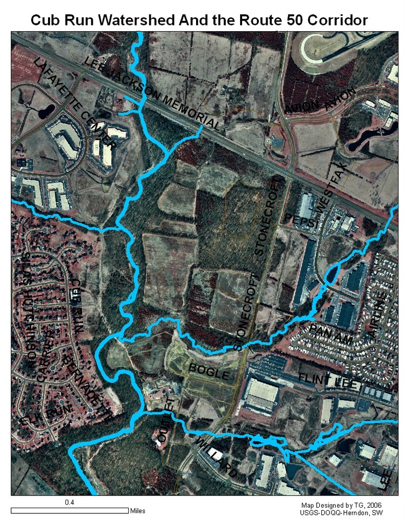
Until I can get out, here is a USGS orthoquad of the corridor near the Loudoun County line. I have highlighted the Cub Run stream system as a visual reference marker.
This aerial photo is from 1998. Much has changed. There is little open space left in this area now.